Hi,
I'm starting to gather some info for my first Moab trip. Any input would be greatly appreciated.
I'm thinking late March (20th) but also thinking this maybe too cold (Arizona guy). So maybe late April?
Places to stay I've looked at VRBO seems you can get a nice place in the $100-$150 range, just need one room.
Would be nice to find a way to secure bike at night, not sure this would be an issue.
Must do rides? I'm looking for easy to moderate trails the first time out, since will be just me.
I do have a GPS so can download trails and find my way.
Bike is a X-Trainer, I'm just a slow trail rider enjoying retirement!
Thanks
Moab Ride
23 posts
• Page 1 of 3 • 1, 2, 3
Re: Moab Ride
![]() by BDM » Mon Jan 23, 2017 3:43 pm
by BDM » Mon Jan 23, 2017 3:43 pm
You going to have someone with you? If solo, that alone would impact route selection.
Might want to avoid Moad during spring break and any jeep jamborees. I would check.
Bruce
Might want to avoid Moad during spring break and any jeep jamborees. I would check.
Bruce
- BDM
- Posts: 40
- Joined: Sat Sep 10, 2016 12:13 pm
Re: Moab Ride
![]() by MAG » Mon Jan 23, 2017 4:09 pm
by MAG » Mon Jan 23, 2017 4:09 pm
Make sure you hit 5 miles of Hell north of Green river. Not as bad as it sounds just a couple test sections, but make sure to take someone with you. We always stay in Moab at Best Western.
- MAG
- Posts: 76
- Joined: Thu Dec 04, 2014 5:59 am
- Location: IA
Re: Moab Ride
![]() by Enmerdeur » Mon Jan 23, 2017 4:21 pm
by Enmerdeur » Mon Jan 23, 2017 4:21 pm
March should be good. Like mentioned stay away on Easter weekend.
This is a good resource
http://www.dirtbikeutah.net/moab.html
Hook and Ladder always fun. Its about 30 miles south of Moab. Do it on your way in or out of town maybe
http://www.riderplanet-usa.com/atv/trai ... e_fcda.htm
This is a good resource
http://www.dirtbikeutah.net/moab.html
Hook and Ladder always fun. Its about 30 miles south of Moab. Do it on your way in or out of town maybe
http://www.riderplanet-usa.com/atv/trai ... e_fcda.htm
2017 KTM 450 XCF
2014 Beta 300 RR
2014 Beta 300 RR
-

Enmerdeur - Posts: 881
- Joined: Fri Oct 11, 2013 2:52 pm
- Location: American Fork, Utah
Re: Moab Ride
![]() by Rv4Bob » Mon Jan 23, 2017 5:32 pm
by Rv4Bob » Mon Jan 23, 2017 5:32 pm
Thanks all a bunch! Looks like I'll be solo, thats why the easy rides.
May try and tag along if i find some riders.
Good idea for on the busy times thanks.
Will do a ride write up afterwards.
May try and tag along if i find some riders.
Good idea for on the busy times thanks.
Will do a ride write up afterwards.
- Rv4Bob
- Posts: 95
- Joined: Wed Aug 19, 2015 8:44 pm
Re: Moab Ride
![]() by andoman » Mon Jan 23, 2017 6:37 pm
by andoman » Mon Jan 23, 2017 6:37 pm
MAG, 5 MOH is WEST of Green River on the South Side of I-70.
Rv4Bob, I've been to Moab twice a year for the last 12 years. Here is my 2 cents worth:
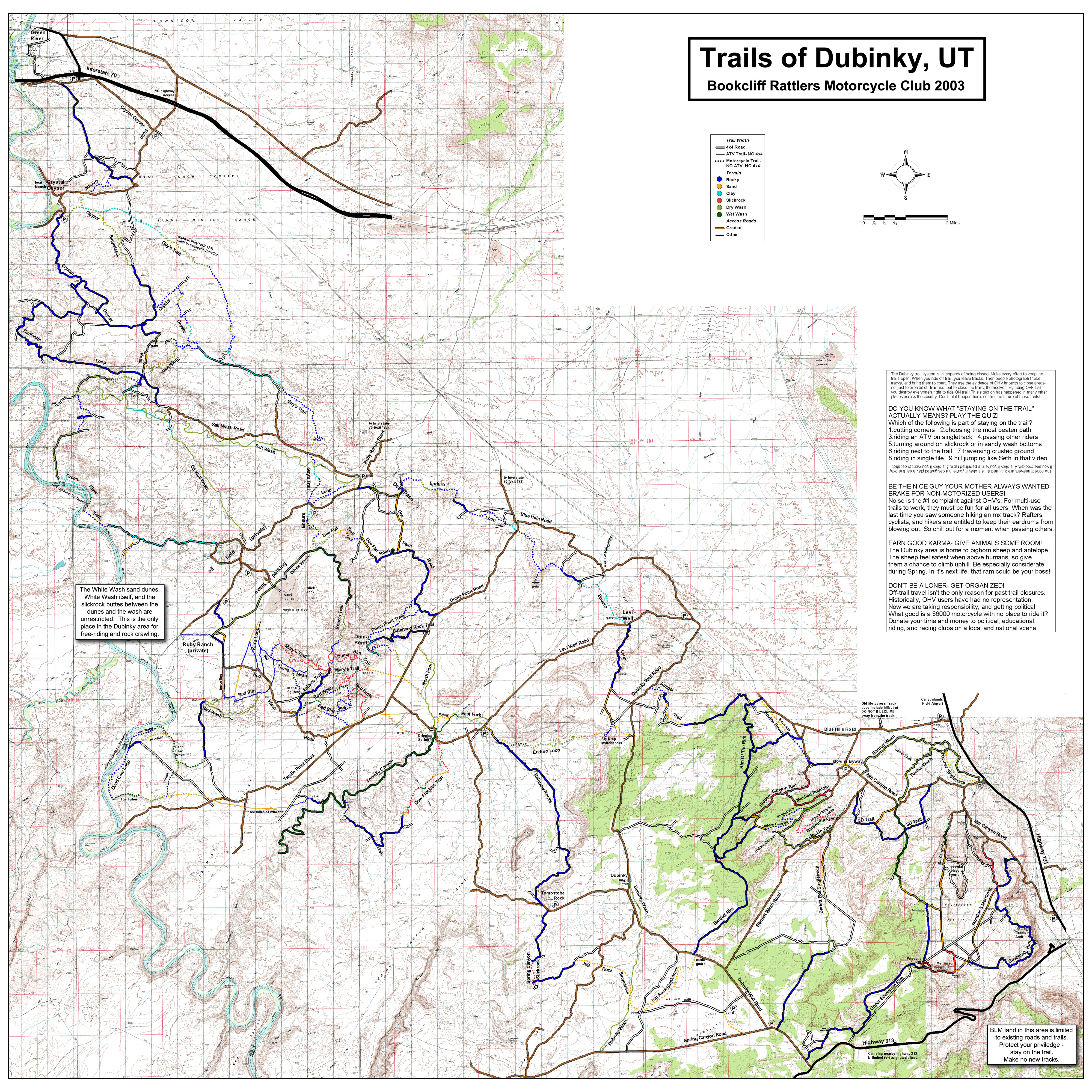
-Download this map to your phone and keep it with you on the trail: http://farm9.staticflickr.com/8152/7118 ... f16e_o.jpg
-Stay in Green River, its closer to the trails in the White Wash area on the above linked map. Less spring break riff-raff in G.R.
-The single track and the variety in the White wash area will more than satisfy you for a trip. The trails are well marked.
-Directions to a great place to stage: East on I-70 and take "Floy" exit. Go south on the ranch road 5 mi. Turn Left (east) on the Power Line Rd. (some maps and signs show it as Blue Hills Road). After 5 mi. turn right (south) on Ten Mile Road. Go 5 mi. and stage on a big sandstone flat on the right side of the road. This will put you just below the Balance Rock Trail on the linked Map. Or you can save some bike hauling and stage right above the White Wash. But then you will be in the company of lots of folks if its a weekend or holiday. I like privacy.... Or you can unload by the pipeline station at the corner of the Ranch Rd. and The Power Line Road. It just means a few miles of dirt road to and fro the trails.
-Ride the following trails:
-Balance Rock (take a pix under it and hope it doesn't fall on you). Just before the end of Balance Rock Trail, take the single track spur to the left to head back to the road. Then go south a mile or so to Mary's trail.
-Mary's Trail (all of it from end to end. I recommend doing the north spur from west to east)
-Red Rocks to Red Butte to Red Slot
-Brian's Trail (pause to rage on the dunes and freestyle on the slick rock south of the Dunes.
-No Name Mesa via Kids Loop East (if in White Wash) or via the west end of Mary's trail.
-The Tubes/Dead Cow Wash. Its less technical to go down The Tubes and up Dead Cow.
-Cow Freckles (out and back).
-10 mile canyon from Dripping Springs or the "gate" about halfway down on the N.W. side. I recommend from the "gate" because the upper end of the wash has mud boggs made by the quads. Either way, watch out for quicksand. Your goal should be to go all the way to the Green River. WATCH OUT FOR DEEEEEP MUD just before the Green River!!!! Its deep enough and sticky enough that you might have to leave your bike there and walk out. It will have a crust on it that looks like a dry lake bed but you will crack through the crust and be stuck fast.
EDIT: I see you are solo, so avoid 10 mile canyon. Its could require an epic group effort...
-Entire Enduro Loop (CW flow recommended). The loop has changed a little from the map, but the signs are easy to follow. Stop and check out the tiny ghost town in the Dee Pass area.
-Guy's Trail to and fro the Crystal Geyser.
The variety will be half the enjoyment. Almost all of these trails are AWESOME single track and are fairly well marked.
Bummer, but the best trails have been closed (upper Red Wash, Duma Rim Trail, and the best part of Cow Freckles).
If you decide to do all this, a trip report to the Forum with lots of pix is expected!!!
Rv4Bob, I've been to Moab twice a year for the last 12 years. Here is my 2 cents worth:
-Download this map to your phone and keep it with you on the trail: http://farm9.staticflickr.com/8152/7118 ... f16e_o.jpg
-Stay in Green River, its closer to the trails in the White Wash area on the above linked map. Less spring break riff-raff in G.R.
-The single track and the variety in the White wash area will more than satisfy you for a trip. The trails are well marked.
-Directions to a great place to stage: East on I-70 and take "Floy" exit. Go south on the ranch road 5 mi. Turn Left (east) on the Power Line Rd. (some maps and signs show it as Blue Hills Road). After 5 mi. turn right (south) on Ten Mile Road. Go 5 mi. and stage on a big sandstone flat on the right side of the road. This will put you just below the Balance Rock Trail on the linked Map. Or you can save some bike hauling and stage right above the White Wash. But then you will be in the company of lots of folks if its a weekend or holiday. I like privacy.... Or you can unload by the pipeline station at the corner of the Ranch Rd. and The Power Line Road. It just means a few miles of dirt road to and fro the trails.
-Ride the following trails:
-Balance Rock (take a pix under it and hope it doesn't fall on you). Just before the end of Balance Rock Trail, take the single track spur to the left to head back to the road. Then go south a mile or so to Mary's trail.
-Mary's Trail (all of it from end to end. I recommend doing the north spur from west to east)
-Red Rocks to Red Butte to Red Slot
-Brian's Trail (pause to rage on the dunes and freestyle on the slick rock south of the Dunes.
-No Name Mesa via Kids Loop East (if in White Wash) or via the west end of Mary's trail.
-The Tubes/Dead Cow Wash. Its less technical to go down The Tubes and up Dead Cow.
-Cow Freckles (out and back).
-10 mile canyon from Dripping Springs or the "gate" about halfway down on the N.W. side. I recommend from the "gate" because the upper end of the wash has mud boggs made by the quads. Either way, watch out for quicksand. Your goal should be to go all the way to the Green River. WATCH OUT FOR DEEEEEP MUD just before the Green River!!!! Its deep enough and sticky enough that you might have to leave your bike there and walk out. It will have a crust on it that looks like a dry lake bed but you will crack through the crust and be stuck fast.
EDIT: I see you are solo, so avoid 10 mile canyon. Its could require an epic group effort...
-Entire Enduro Loop (CW flow recommended). The loop has changed a little from the map, but the signs are easy to follow. Stop and check out the tiny ghost town in the Dee Pass area.
-Guy's Trail to and fro the Crystal Geyser.
The variety will be half the enjoyment. Almost all of these trails are AWESOME single track and are fairly well marked.
Bummer, but the best trails have been closed (upper Red Wash, Duma Rim Trail, and the best part of Cow Freckles).
If you decide to do all this, a trip report to the Forum with lots of pix is expected!!!
- andoman
- Posts: 60
- Joined: Wed May 13, 2015 9:27 am
Re: Moab Ride
![]() by Lonesome Dave » Mon Jan 23, 2017 6:52 pm
by Lonesome Dave » Mon Jan 23, 2017 6:52 pm
Hey Rv4Bob, we have a group going to Moab on April 29th from South Dakota. I'm not sure if I'm going just yet, but I think so.
dakotadualsportriders.com or link to the thread; http://www.dakotadualsportriders.com/sm ... pic=2300.0
I've never been there before, but most of them have.
I'll send you a pm. LD
dakotadualsportriders.com or link to the thread; http://www.dakotadualsportriders.com/sm ... pic=2300.0
I've never been there before, but most of them have.
I'll send you a pm. LD
Older - Wiser - Faster !
-

Lonesome Dave - Posts: 133
- Joined: Tue Mar 08, 2016 9:21 pm
- Location: Black Hills, SD
Re: Moab Ride
![]() by Rv4Bob » Mon Jan 23, 2017 6:58 pm
by Rv4Bob » Mon Jan 23, 2017 6:58 pm
Thanks Andoman, tons of good info, looking forward to try some of those trails.
Lonesome Dave, may take you up on this if my march trip goes south.
Will check out your site.
Thanks
Lonesome Dave, may take you up on this if my march trip goes south.
Will check out your site.
Thanks
- Rv4Bob
- Posts: 95
- Joined: Wed Aug 19, 2015 8:44 pm
Re: Moab Ride
![]() by Enmerdeur » Mon Jan 23, 2017 9:44 pm
by Enmerdeur » Mon Jan 23, 2017 9:44 pm
andoman wrote:-Download this map to your phone and keep it with you on the trail: http://farm9.staticflickr.com/8152/7118 ... f16e_o.jpg
This map is a bit out of date. Some the routes shown on it are now closed to motorized vehicles. What is open is fairly well marked.
Andoman covered it well
2017 KTM 450 XCF
2014 Beta 300 RR
2014 Beta 300 RR
-
Enmerdeur - Posts: 881
- Joined: Fri Oct 11, 2013 2:52 pm
- Location: American Fork, Utah
Re: Moab Ride
![]() by SAM313 » Fri Jan 27, 2017 8:50 am
by SAM313 » Fri Jan 27, 2017 8:50 am
Easter Jeep safari is April 8th through the 16th. Many 4X4 trails are closed just for their use but there are still unlimited places to ride. I live here but usually ride solo. Similarly to you, retired and don't heal as fast. Currently on a Freeride but waiting upon a BYOB delivery so I can extend my riding range...... Feel free to hit me up when your trip gets closer and we can get in a ride or two.
- SAM313
- Posts: 2
- Joined: Tue Jan 24, 2017 8:34 am
23 posts
• Page 1 of 3 • 1, 2, 3
Return to General Discussions & Announcements
Who is online
Users browsing this forum: No registered users and 103 guests